Work across three provinces and a dozen commodities

A selection from recent projects. Clients, license numbers and coordinates are withheld; the methods and results are described as they happened.

Porphyry Cu-AuBalochistanRS · geophysics · geochemistry · regulatory

Exploration license and proposed extensions

Satellite alteration mapping across the license and its neighbors, followed by ground magnetic and soil geochemistry surveys over the target areas. We reviewed the contractor's magnetic data as it came in, assessed adjoining blocks for acquisition, and wrote the remote sensing justification that went to the department with the extension application.
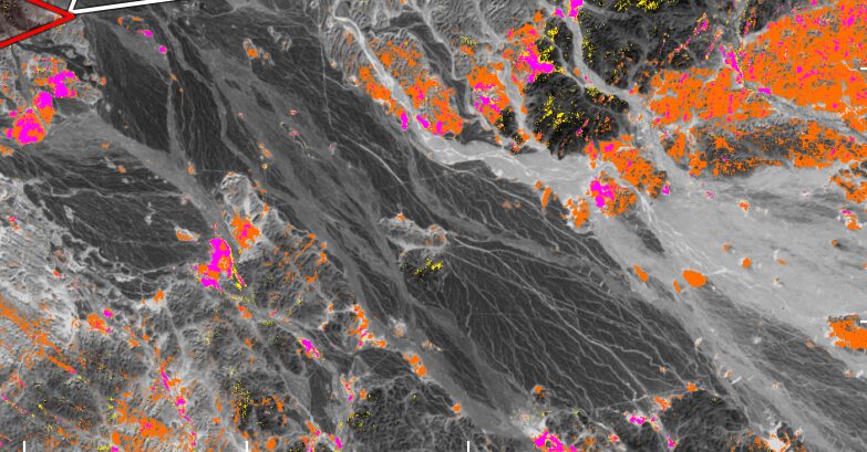
Alteration anomaly map in orange and magenta over a grayscale desert range
Fig. 1Clay and ferric-iron anomalies used to justify the extension areas.
Porphyry Cu-AuBalochistanRS · structure · target ranking

A whole-license remote sensing assessment

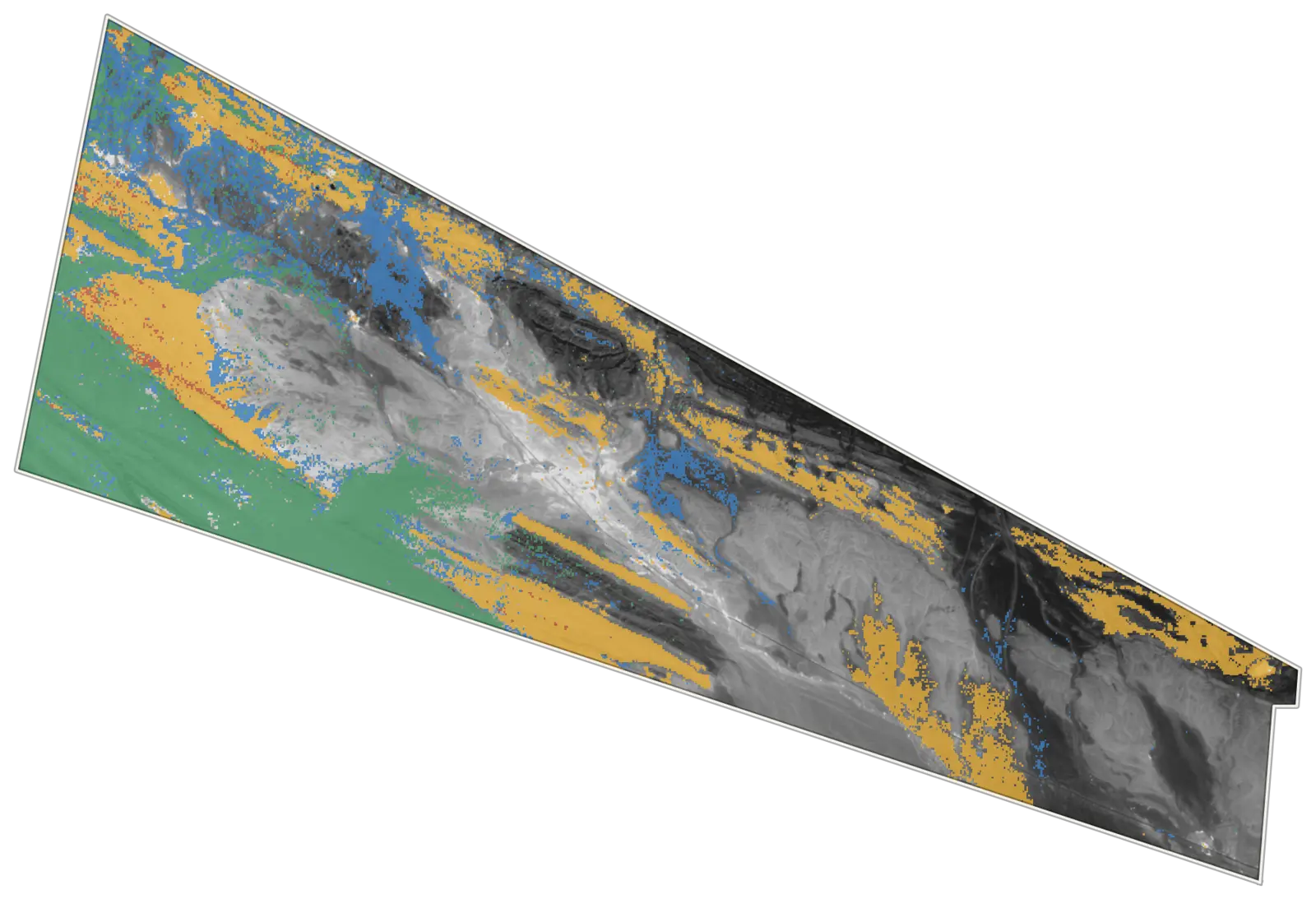
Multispectral and hyperspectral data combined with fault and lineament interpretation, mapped into dominant mineral groups and scored into follow-up areas. The report said plainly where the strongest responses were rock type rather than alteration, so the field budget went to the ground that deserved it.

License block in grayscale with ochre, green and blue patches showing dominant mineral groups
Fig. 2Dominant mineral groups across the license.white mica, clayschlorite, epidotecarbonatemixed
W · Au · Cu · PGMGilgit-BaltistanRS · mapping · geophysics design

Exploration blocks in glaciated terrain

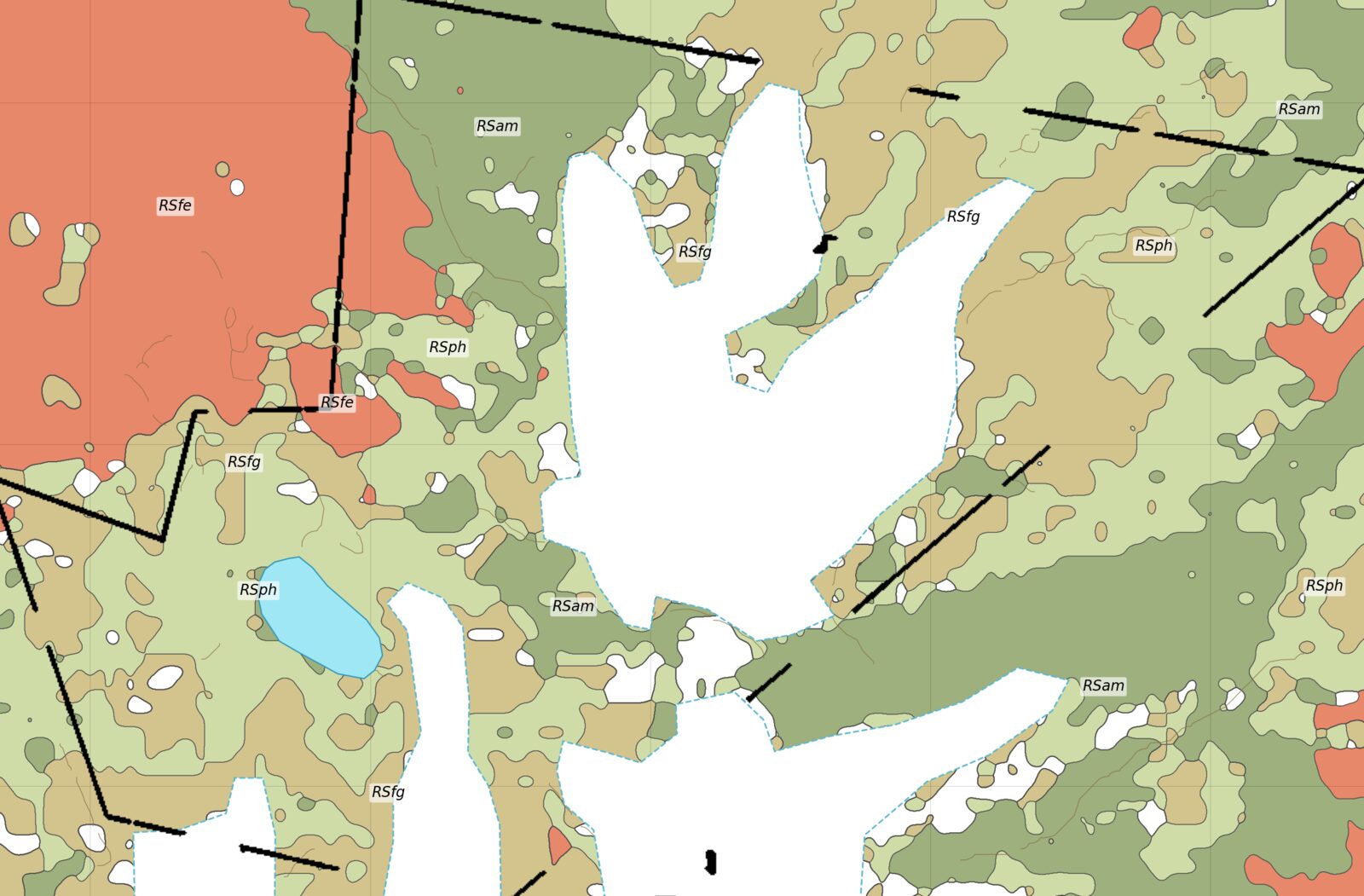
Remote sensing reports and an interpreted litho-spectral map separating iron-oxide gossans from the metamorphic rocks between glaciers. Geological mapping followed, with a magnetic survey planned for terrain too steep for a regular grid: lines laid out along ridges and walkable slopes.

Litho-spectral interpreted geological map with salmon, olive and tan units
Fig. 3Litho-spectral units; salmon marks the iron-oxide zone ranked first.
Cu-W skarn and greisenKhyber PakhtunkhwaRS · targeting

Targeting under forest and in high valleys

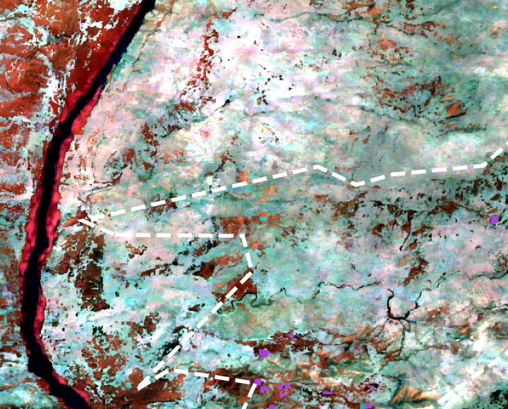
A targeting workflow for skarn and greisen: spectral classification, hyperspectral comparison with reference minerals, and vegetation-stress mapping where forest hides the rock. Results were ranked into follow-up areas inside and between licenses, then checked against field lithology.

False-color image with a river, dashed license lines and purple targets
Fig. 4Tourmaline and copper targets between license blocks.
Placer goldGilgit-BaltistanSampling · grade mapping · plant design · reporting

River placer leases, from bulk samples to a plant

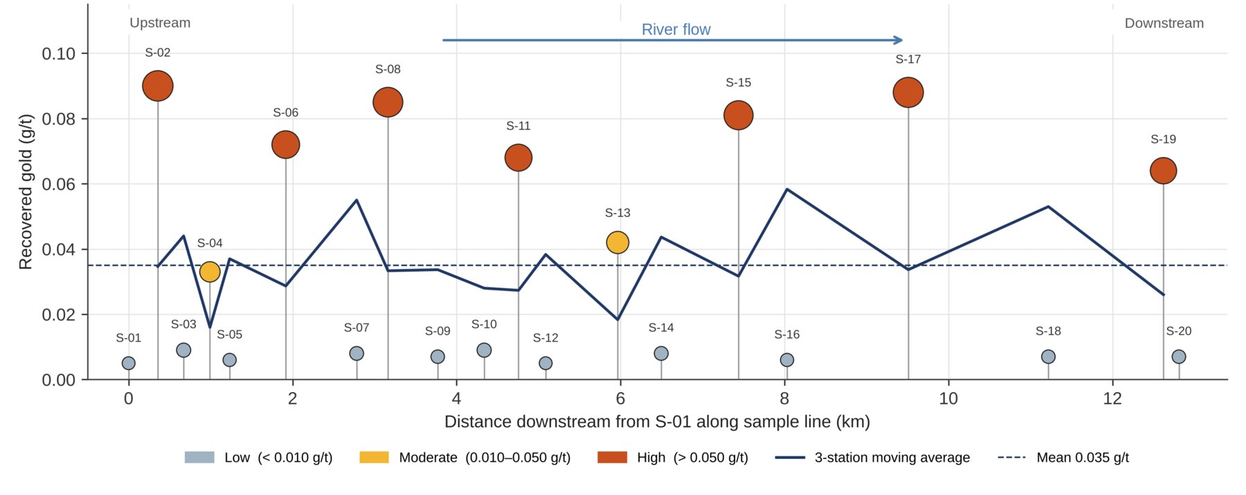
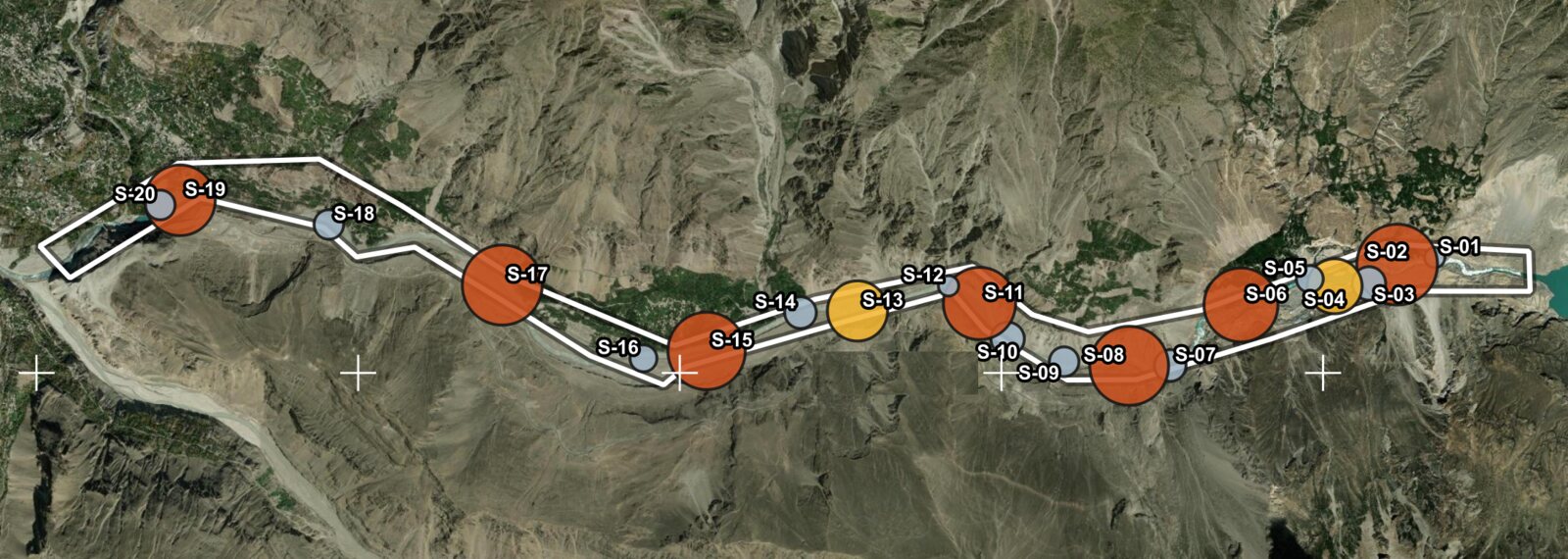
Bulk sampling along a river placer lease, with recovered gold mapped station by station and plotted downstream so the richer reaches stand out. The results fed the geological report for the department and a recovery plant flowsheet sized for local fabrication. Exploration plans, budgets and an investor proposal followed for further river leases.

Chart of recovered gold at each sample station along the river, with high-grade stations as large red circles and a moving average line
Fig. 5Recovered gold by station, upstream to downstream, with a moving average.
Satellite image of a mountain river valley with a white lease outline and sample stations drawn as circles sized by gold grade
Fig. 6Bulk sample stations along the lease, circles scaled to recovered gold: gray low, yellow moderate, red high.
BariteBalochistanRS · processing plant

Prospect ranking and a working washing plant

Barite occurrences ranked from satellite data before the field visit. At the plant, a gravity flowsheet from crusher to classifier and shaking tables, tonnage reporting, and product grading against buyer specifications.

Prospects
Rankedbefore fieldwork
Circuit
Gravityspirals and tables
Reporting
Dailytonnage and grade
Regulatory and GISGilgit-Baltistan, Balochistan, KPFilings · maps

Keeping titles in good standing

Geological reports, work plans, production and CSR plans prepared in response to department letters for mining leases and exploration licenses, with boundary maps, area statements and GIS compilations for overlap checks and opportunity screening.

Filings
EL and MLto department format
Maps
Boundarieswith area statements
Replies
Point by pointto department letters

Who you will work with

Zarkaan Geosystems is led by Ammar Hashmi, a geophysicist who has worked in oil and gas data management, field geophysics and mineral exploration.

2025 – 2026Manager Exploration, Siddiqsons Mining. Exploration, remote sensing, geophysics and processing plants across Balochistan, KP and Gilgit-Baltistan.
EarlierData Management Geophysicist, Pakistan Petroleum Limited. Seismic, well and G&G data governance.
EarlierGeophysicist and Site Operations Supervisor, Bore & Bore.
2019BSc Geophysics, Bahria University.

Tools: QGIS, Google Earth Engine, Python, Leapfrog Geo and ArcGIS.

Similar ground, similar problem?

Tell us what you are working on.